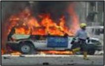
 HazMapper is a tool for First Responders and Emergency Personnel that provides on-site, real time geographical situational awareness—without relying on the internet. HazMapper enhances responders capabilities to quickly identify, record, and share a common operational picture of any HazMat/CBRNE/IED incident, integrating real-time maps, HazMasterG3 threat information, along with ALOHA and HPAC plumes, IED blast zones and other GIS overlays. HazMapper is a tool for First Responders and Emergency Personnel that provides on-site, real time geographical situational awareness—without relying on the internet. HazMapper enhances responders capabilities to quickly identify, record, and share a common operational picture of any HazMat/CBRNE/IED incident, integrating real-time maps, HazMasterG3 threat information, along with ALOHA and HPAC plumes, IED blast zones and other GIS overlays.
 HazMapper enables First Responders to deploy with a tool which provides unique capabilities in the field. Optionally using GPS to determine real time, hands free location, the user can work with standard, pre-loaded maps ranging in scale from North America down to street level detail anywhere in the United States. In addition to the standard, accurate, and detailed maps; the user can load custom maps using industry standard ESRI overlay format, for maximum GIS interoperability. Interacting with existing GIS data is a strength of HazMapper; in addition to an extensive suite of standard map interaction tools like pan, dynamic pan, zoom, rapid zoom, and map centering, HazMapper has the ability to save and reload views - not just the incident specific overlays and drawings layered on a map. These views can even be shared with other users of HazMapper. HazMapper enables First Responders to deploy with a tool which provides unique capabilities in the field. Optionally using GPS to determine real time, hands free location, the user can work with standard, pre-loaded maps ranging in scale from North America down to street level detail anywhere in the United States. In addition to the standard, accurate, and detailed maps; the user can load custom maps using industry standard ESRI overlay format, for maximum GIS interoperability. Interacting with existing GIS data is a strength of HazMapper; in addition to an extensive suite of standard map interaction tools like pan, dynamic pan, zoom, rapid zoom, and map centering, HazMapper has the ability to save and reload views - not just the incident specific overlays and drawings layered on a map. These views can even be shared with other users of HazMapper.
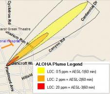
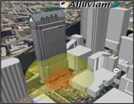 Documenting and displaying critical incident information in HazMapper is simple and intuitive. HazMapper has a full suite of drawing tools including; rectangles, ellipses, lines, points, and text. All of the shapes have customizable text, font, fill colors and opacities, and line style settings. These features provide the user with the flexibility add overlays to convey critical incident specific information needed during emergency situations. Most importantly, HazMapper supports CBRNE threat overlays directly from HazMasterG3, displaying isolation and evacuation distances for enhanced planning, response, and recovery to improvised explosive devices (IEDs), improvised nuclear devices (INDs), and toxic chemical agent releases, along with drag and drop integration of ALOHA or HPAC plumes with direct visualization in Google Earth, and is the only available system with this capability. GIS files from ESRI can also be placed onto HazMapper maps, and injected into Google Earth, for either planning or response needs. Documenting and displaying critical incident information in HazMapper is simple and intuitive. HazMapper has a full suite of drawing tools including; rectangles, ellipses, lines, points, and text. All of the shapes have customizable text, font, fill colors and opacities, and line style settings. These features provide the user with the flexibility add overlays to convey critical incident specific information needed during emergency situations. Most importantly, HazMapper supports CBRNE threat overlays directly from HazMasterG3, displaying isolation and evacuation distances for enhanced planning, response, and recovery to improvised explosive devices (IEDs), improvised nuclear devices (INDs), and toxic chemical agent releases, along with drag and drop integration of ALOHA or HPAC plumes with direct visualization in Google Earth, and is the only available system with this capability. GIS files from ESRI can also be placed onto HazMapper maps, and injected into Google Earth, for either planning or response needs.
HazMapper's ability to save all of the geographic informa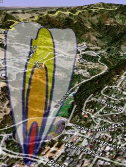 tion and the incident overlay information added by an incident commander provides very useful and unique EOC capabilities. By saving map views, threat rings, ALOHA or HPAC plumes and custom overlays a user is able to create a library of scenario pre-plans before an incident takes place. Ingress and egress routes can be planned before an emergency and simply loaded when needed. Evacuation areas can be defined. Resources can be pre-positioned and easily located. As a situation is developing, this information can be used as a template to accelerate the response, and as the incident evolves, so can the overlay information. Sharing the updated incident scene can keep everyone in the loop – from the on-scene EOC, to remote operation centers. tion and the incident overlay information added by an incident commander provides very useful and unique EOC capabilities. By saving map views, threat rings, ALOHA or HPAC plumes and custom overlays a user is able to create a library of scenario pre-plans before an incident takes place. Ingress and egress routes can be planned before an emergency and simply loaded when needed. Evacuation areas can be defined. Resources can be pre-positioned and easily located. As a situation is developing, this information can be used as a template to accelerate the response, and as the incident evolves, so can the overlay information. Sharing the updated incident scene can keep everyone in the loop – from the on-scene EOC, to remote operation centers.
 Perhaps HazMapper's greatest asset is its tight integration with HazMasterG3® integrated HazMat/CBRNE/IED decision support software. HazMasterG3® delivers a broad range of threat identification capabilities along with comprehensive response guidance for 165,000+ CBRNE agents and trade names; includes the most advanced improvised explosive device threat-identification capability available today, and nearly 4X more radioactive isotopes as other legacy systems. While HazMasterG3® has been designed to be the most comprehensive mobile HazMat/CBRNE/IED decision support system available, there are still situations where user developed reference materials, forms, checklists or other organization specific reference aids such as incident maps and overlays created in HazMapperTM, may be available for use, and HazMasterG3® can effortlessly be extended to incorporate this site and incident specific information. HazMapperTM provides the ability to view HazMasterG3®’s CBRNE threat data on GPS based street maps. The effortless display of threat data from HazMasterG3®, HazMapper's dynamic mapping with ALOHA and HPAC plumes is a critical resource in any HazMat/CBRNE/IED response situation. Perhaps HazMapper's greatest asset is its tight integration with HazMasterG3® integrated HazMat/CBRNE/IED decision support software. HazMasterG3® delivers a broad range of threat identification capabilities along with comprehensive response guidance for 165,000+ CBRNE agents and trade names; includes the most advanced improvised explosive device threat-identification capability available today, and nearly 4X more radioactive isotopes as other legacy systems. While HazMasterG3® has been designed to be the most comprehensive mobile HazMat/CBRNE/IED decision support system available, there are still situations where user developed reference materials, forms, checklists or other organization specific reference aids such as incident maps and overlays created in HazMapperTM, may be available for use, and HazMasterG3® can effortlessly be extended to incorporate this site and incident specific information. HazMapperTM provides the ability to view HazMasterG3®’s CBRNE threat data on GPS based street maps. The effortless display of threat data from HazMasterG3®, HazMapper's dynamic mapping with ALOHA and HPAC plumes is a critical resource in any HazMat/CBRNE/IED response situation.
|
